
Course Information
Land Navigation
 Before you decide to leave the trail and venture into the backcountry, it's important to learn and practice land navigational skills. Our modern day reliance on GPS navigation and cell phone apps for trails has caused us to neglect our age-old land navigation skills. Google Maps and GPS are amazing - as long as you have a signal, connectivity, and a fully charged battery. But what happens when the device goes down?
Do you know how to use a map and compass to navigate and self-rescue if you suddenly couldn't use (or trust) any electronics? Even with modern technology, hikers and backpackers get lost and die all the time. SAR teams call it: death by GPS. Maps and compasses are powerful tools and they are not as confusing or complicated as you might think. But they can't help you if you don't know how to use them. Like any tool, trying to use them without knowing how could even get you killed. Learning the basics of Land Navigation might save your life in a wide range of survival scenarios. Knowing the basics of using a map and compass not only provide backup navigation if you're deep in the wilderness, but they also offer a fun and refreshingly simple way to navigate. This course will teach you critical new skills, and help you improve your current map reading skills.
In our newest course, you will learn:
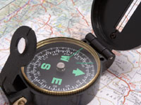
- Components of a compass
- Components of a topographical map
- Adjusting for declination
- How to Shoot an azimuth
- Shooting a reverse azimuth
- How to identify terrain features
- Land/Terrain and Map Association
- How to use terrain features as steering markers
- And much more!
This class will be held August 3rd, 2019
9am to 4pm at our Stafford location.
$127 per person